


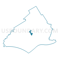
UPPER PROVIDENC TWP PCT 01, Delaware County, Pennsylvania
About
Outline

Summary
| Unique Area Identifier | 659438 |
| Name | UPPER PROVIDENC TWP PCT 01 |
| County | Delaware County |
| State | Pennsylvania |
| Area (square miles) | 0.92 |
| Land Area (square miles) | 0.91 |
| Water Area (square miles) | 0.00 |
| % of Land Area | 99.68 |
| % of Water Area | 0.32 |
| Latitude of the Internal Point | 39.92385200 |
| Longtitude of the Internal Point | -75.40314990 |
Maps

Graphs
Select a template below for downloading or customizing gragh for UPPER PROVIDENC TWP PCT 01, Delaware County, Pennsylvania


Neighbors
Neighoring Voting District (by Name) Neighboring Voting District on the Map
- MEDIA PCT SOUTHERN, Delaware County, PA
- MEDIA PCT WESTERN, Delaware County, PA
- MIDDLETOWN TWP DIST 01 PCT 02, Delaware County, PA
- MIDDLETOWN TWP DIST 02 PCT 01, Delaware County, PA
- MIDDLETOWN TWP DIST 03 PCT 01, Delaware County, PA
- MIDDLETOWN TWP DIST 04 PCT 01, Delaware County, PA
- NETHER PROVIDENCE TWP WD 02, Delaware County, PA
- NETHER PROVIDENCE TWP WD 03, Delaware County, PA
- NETHER PROVIDENCE TWP WD 04, Delaware County, PA
- UPPER PROVIDENCE TWP PCT 04, Delaware County, PA
Top 10 Neighboring County Subdivision (by Population) Neighboring County Subdivision on the Map
- Middletown township, Delaware County, PA (15,807)
- Nether Providence township, Delaware County, PA (13,706)
- Upper Providence township, Delaware County, PA (10,142)
- Media borough, Delaware County, PA (5,327)
Top 10 Neighboring Place (by Population) Neighboring Place on the Map
Top 10 Neighboring Unified School District (by Population) Neighboring Unified School District on the Map
Top 10 Neighboring State Legislative District Lower Chamber (by Population) Neighboring State Legislative District Lower Chamber on the Map
Top 10 Neighboring State Legislative District Upper Chamber (by Population) Neighboring State Legislative District Upper Chamber on the Map
Top 10 Neighboring 111th Congressional District (by Population) Neighboring 111th Congressional District on the Map
Top 10 Neighboring Census Tract (by Population) Neighboring Census Tract on the Map
- Census Tract 4108, Delaware County, PA (7,719)
- Census Tract 4072.01, Delaware County, PA (5,135)
- Census Tract 4074.01, Delaware County, PA (4,057)
- Census Tract 4079.01, Delaware County, PA (3,944)
- Census Tract 4072.02, Delaware County, PA (3,790)
- Census Tract 4071.02, Delaware County, PA (3,169)
- Census Tract 4075.02, Delaware County, PA (2,987)
- Census Tract 4079.02, Delaware County, PA (2,760)
- Census Tract 4075.01, Delaware County, PA (2,340)